Mosaic Images
Generally when collecting data from sources such as satellite, airplanes, or unmanned vehicles (UAV); multiple images must be combining together. The image generally contain overlaps. These images can be combined together using multiple different software applications, both designed for geospatial technologies and those for other uses.
The concept of mosaic images varies with the software and sensor collecting the data, so before looking at combining an image, it is critical to understand what is contained within an image file. The detector section of this course has a discussion about the devices used to collect imagery data. In another section the different wavelengths of the electromagnetic spectrum are discussed. This section will discuss images once collected by the sensor into the creation of a final mosaic. This lesson will show how this can be done in different applications. The assignments will require the use of different software applications.
In this discussion UAVs will be the collection device, but other devices with sensors could have been used for the data collection.
Image
The digital image collected can be in any of the wavelength families such as visible, IR, near IR. The information discussed in this section will be true in general for ground based cameras (such as a cell phone) as well as aerial cameras. This discussion will assume that the camera on the vehicle and the control applications have been set properly set to collect visible light imagery and multiple images were captured. Many different software packages can provide image data, for this example IrfanView is used and is a free image software which can be downloaded here. The image below is a single frame taken by a UAV over the Southwest Campus of Jefferson Community and Technical College (JCTC) in 2018 showing a part of the Library. The image can be downloaded at:
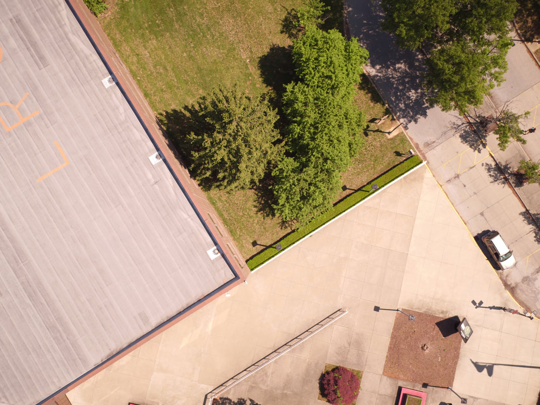
Figure 1: Image Collected by GeoTech Center, Library on the JCTC Southwest Campus, pilot Chris Wright
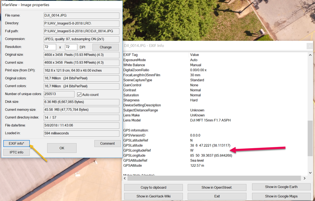 Figure 2: EXIF Data from Figure 1 taken with UAS, pilot Chris Wright
Load the single image into IrfanView, select the image tab and then select information, next select EXIF (Exchangeable Image File) info. In the EXIF data there is lots of information about the image, which includes the GPS location, it can be assumed that the GPS location is the location of the center of the frame. The data also gives many other parameters that may be useful. Every images in this flight has this type of information, but so does photographs taken with a cell phone camera. This type of information allows for photographs to be automatically referenced on a map if the application reads the EXIF data.
The image file is in a jpeg format, which means the data has been compressed. A RAW format is an uncompressed format that contains all image characteristics, but occupies a much great amount of storage, most images created by a camera is saved in a compressed format, but some upper end cameras will save in the RAW format, but to view the image may require specialized software.
Since the camera recorded the GPS position of the UAV when the image was taken, a map can be made of the flight path, using this position data as a reference, also the flight software can record a similar set of data on what was planned. In the image below the yellow squares are the location of the camera when the image was taken. The flight plan can be determined the mission planning software or using the time stamp saved in the EXIF file. The image shown above is the 14 image in the flight path. To determine the position of the camera start counting from the first image, which is in the upper right of the image.
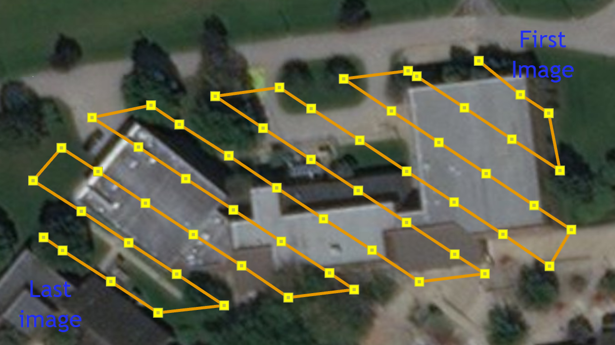
Figure 3: Flight Path by GeoTech Center, pilot Chris Wright, 2018.
Once the images are taken, the center location of each image is known, but the alignment around that point has not been determined. Think of taking a printed image that has a push pen in the center and attached to a map. The image can be rotated in any orientation and also if printed on a flexible sheet stretched appropriately.
Since the images cover very little area of the total building, it requires that the images must be stitched together (mosaic) and properly orientated. This will be accomplished from an open source software developed by Microsoft Research known as ICE (Image Composite Editor) and also within a geospatial software package (ArcGIS Pro). The first example will utilize ICE.
Since the images cover very little area of the total building, it requires that the images must be stitched together (mosaic) and properly orientated. This will be accomplished from an open source software developed by Microsoft Research known as ICE (Image Composite Editor) and also within a geospatial software package (ArcGIS Pro). The first example will utilize ICE.
