Platforms
There are two major types of platforms in which detectors are used for imagery:
Chapter from The Geographic Information Science and Technology Body of Knowledge on Remote Sensing Platforms by Ken Yanow from Southwestern College in California, chapter link.
- A terrestrial based detector might be a device mounted to a vehicle, such as a van used to measure the height of overpasses on an Interstate highway, using a LiDAR detector[1].
- Aerial detectors are classified in one of three groups:
- satellites
- manned aircraft
- unmanned aerial vehicles
Chapter from The Geographic Information Science and Technology Body of Knowledge on Remote Sensing Platforms by Ken Yanow from Southwestern College in California, chapter link.
Historical Remote Sensing Platforms
Before developing an understanding of the current platforms, a brief historical review of platforms used in the 1800s and 1900s will be explored. Much of the content of this section is derived from Professor Ken Yanow of Southwestern College in California.
The first remote sensing of the Earth was created utilizing a balloon as the platform in 1858 by Gaspard Felix Tournachon (Felix Nadar) in France with his detector being a photographic camera. The images created are very impressive when you realize the motion that the balloon was experiencing even though it was tethered. In addition film of this day was extremely slow, i.e. was not very sensitive to light, thus the shutter must remain open for an extended period of time.
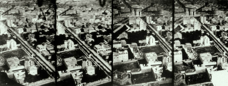
Figure 1: Nadar's 1868 aerial image of Paris, taken from a tethered balloon (Wikimedia Commons)
In 1884 the Kodak company developed the first roll film, thus a photographer did not need to be present with the camera, as was required with glass plate photography.
The first non-manned aerial photography flight was with a kite in 1888 by Arthur Batut in France, it used a slow burning fuse to trigger the camera shutter. His kite was equipped with an altimeter so the elevation would be documented with the film as well as the landscape below.
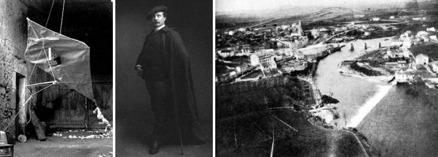
Figure 2: Arthur Batut’s 1888 aerial kite and resulting imagery (Wikimedia Commons)
Next came the use of pigeons with a camera mounted on them, the first recorded flight was in 1903. The potential problems of using birds as a platform are many, but the smaller size of the cameras was another major step forward.
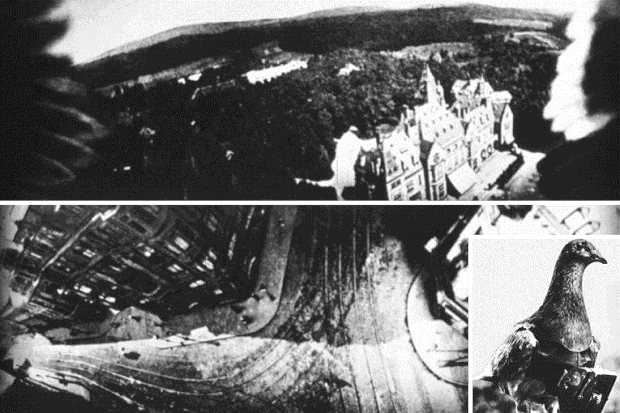
Figure 3: Julius Neubranner’s pigeon-mounted aerial camera, 1903 (Wikimedia Commons)
In the 1960s satellites became the new aerial platform for imagery.
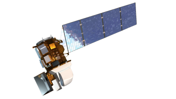 Figure 4: Light Detection and Ranging, Image from Wikipedia
Satellites
A satellite in orbit around the earth, in general, has the lowest image resolution, but does provide a wide field of view and is periodic, which is great for measuring changes. Some satellites are placed in a geosynchronous orbit[2], but to achieve this stationary position requires that the satellite be much farther from the surface of the earth. Thus the area viewed while constant is much larger and produces less localized detail. A weather satellite is an example of a non-periodic satellite in a geosynchronous orbit. One of the down sides of a satellite is the fact that these orbiting platforms are outside of the atmosphere of the earth, which limits the effective transmission of certain wavelengths through the atmosphere. Then there is the lack of data collection on days in which the cloud cover obscures the surface of the earth (unless the satellite is used for weather). Another issue is the size of each individual pixel, which are large, making small objects unidentifiable. In general, satellites use passive detectors.
One of the most employed periodic satellites used for remote sensing is Landsat. Landsat 8 (launched in 2013) orbits the earth in a polar orbit and images every part of the earth in multiple spectral bands every 16 days.[3] The pixel size varies with different sensors/detectors/instruments. The satellite has 4 visible bands with a resolution of 30 meters, four near IR bands at 30 meters, panchromatic band with a resolution of 15 meters and two thermal IR bands with a 100 meter resolution.[4] Also available is data from previous Landsat satellites. Note; Landsat 7 is still active. As one would expect there have been several Landsat satellites each with improvements over the previous, with most having an active life of about five years. Landsat 6 was never an active satellite due to a launch failure. Landsat 9 is due to be launched around 2020.
There are other remote sensing satellites that have been launched for military purposes by the United States and other nations. Some of the military satellites can be moved to 'hot spots'. While this discussion centers on Landsat because it is one of the most common satellites used for remote sensing there are other remote sensing platforms. It is important to note the resolution of the orbiting satellites.
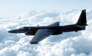 Figure 3: Lockheed U2S, Image from Wikipedia
Manned Aircraft
In general, a manned aircraft flies at a few thousand feet above the ground to photograph a much smaller area than would be accomplished with a satellite, the detectors also have considerable less atmosphere for the signals to pass through. In addition, an aircraft can be scheduled at the specific time needed instead of when the path of the satellite brings the instruments over the target. The resolution of the detected information is a much smaller area, down to resolutions of less than 2 inches per pixel. This finer resolution dramatically increases the amount of data received, which can create storage issues. Oblique imagery[5] can also be taken with aircraft using multiple cameras taking simultaneous images that can be used to build a three dimensional model.
In general, a manned aircraft flies at a few thousand feet above the ground to photograph a much smaller area than would be accomplished with a satellite, the detectors also have considerable less atmosphere for the signals to pass through. In addition, an aircraft can be scheduled at the specific time needed instead of when the path of the satellite brings the instruments over the target. The resolution of the detected information is a much smaller area, down to resolutions of less than 2 inches per pixel. This finer resolution dramatically increases the amount of data received, which can create storage issues. Oblique imagery[5] can also be taken with aircraft using multiple cameras taking simultaneous images that can be used to build a three dimensional model.
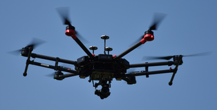 Figure 4: DJI Matrice 600 Pro, Image by the author.
Unmanned Aerial Vehicles
Unmanned Aerial Vehicle (UAV) or an Unmanned Aerial System (UAS), which are referred to as drones, can take multiple configurations. The UAV is the aircraft, while the UAS is the complete system used. The size of these devices can vary from a few grams to those which are extremely large and used by the military. For this discussion only those used for non-military individualized geospatial purposes will be discussed. Many of these weigh less than 55 pounds which means they are generally referred to as small UAS (sUAS). These vehicles usually fall in to two classifications, those that are fixed wing and those with multiple rotors. The multi-rotor aircraft, in general, are stable platforms, that can hover and can carry high resolution cameras, used for flying relatively small areas. Many of the multi-rotor devices are used as a stationary platform and the camera can be controlled. Some uses include; fire and police events, movie making, search operations and 360 flights around an object. The fixed wing vehicles are meant to fly a pathway and do not hover. The speed of the devices varies with manufacturer but can exceed 50 miles per hour. Since these devices are relatively close to the ground, usually less than 400 feet, the size of an individual pixel can be less than a centimeter on a side. A large amount of data can be collected, each point on the surface of the earth in the study area can be in multiple images due to image overlap. Thus a three dimensional point cloud can be constructed so a software analysis can be used to determine volumetric measurements. Since these vehicles are in motion, care must be taken in setting the shutter speed[6] of the cameras as well as f-stop[7], focal length of the lens[8] and ASA/ISO[9].
[1] Lidar: Light Detection and Ranging http://oceanservice.noaa.gov/facts/lidar.html
[2] A geosynchronous orbit is achieved when the satellite orbits the earth at the exact same angular velocity as the earth turns, thus the satellite makes one revolution around the earth in a 24 hour period. This is achieved by placing the satellite at specific distance from the surface of the earth.
[3] http://landsat.usgs.gov/landsat8.php
[4] http://landsat.usgs.gov/band_designations_landsat_satellites.php
[5] Oblique imagery can be used to make three dimensional measurements of buildings, many cities use this type of images to determine changes in the community.
[6] Shutter speed is how long the detector can view the target usually in hundreds or thousands of a second.
[7] f-stop refers to the aperture of the lens, the smaller the number the larger opening of the lens. The larger the open the less depth of field, which is how accurate the focus of the camera.
[8] The smaller the focal length the larger the area that is visible, but also the greater the distortion at the edges of the image. A typical focal length would generally be between 30 and 70 mm.
[9] ASA/ISO refers to the speed of the chip, the smaller the number the less sensitive, but less graininess in an image, the higher the number the greater chip speed, but more distortion. The graininess is electronic ‘noise’.
